


Building information modeling (BIM) has, by now, been firmly established as the “go-to” technology globally for the design and construction of buildings. While there are many building design and construction firms who still have to get started on their BIM implementations let alone being well on their way to transitioning from CAD to BIM, there is no doubt that this is the way forward for the building industry; that sooner or later, they have to make the leap. The technology whereby a building is represented as an intelligent 3D model with data-rich components that can carry information about themselves and their relationship to other components now seems so obviously superior than the earlier CAD technology where a building was represented primarily by generic 2D lines for the purpose of designing and constructing it. The benefits of BIM are undisputed, even though not every firm is able to derive them as quickly as they would like.
Now that BIM has conquered the building industry and is here to stay, the question arises to whether it can be applied to a larger scale, going beyond a building, to a street, a neighborhood, a city, and so on. We’re not talking about using the same BIM tools that we have for buildings to infrastructure, as that would be impossible—the individual “components” making up infrastructure, such as roads, utilities, bridges, and so on, are quite different from the walls, beams, slabs, and other components comprising buildings. (There is some overlap, of course, as buildings are also part of infrastructure, but more on that later.) So what we’re talking about is applying the same “information modeling” concept to infrastructure that we have done for buildings, where all the individual components making up a city’s infrastructure are represented by intelligent data-rich 3D models that carry information about themselves and their relationship to other components.
Just as the ultimate scenario with BIM for buildings is to have a single model that is used for design, construction, and ongoing facilities management, imagine the ultimate scenario of applying the same concept to infrastructure—a live intelligent 3D model of every city that represents all its transportation networks, utilities, zones, open spaces, buildings, and any other infrastructure components, all physically located within a geographical map and related to each other. So, for instance, if you were to select any street in the city, you could immediately find out where it is located, what are the overhead and underground utilities that run through it, which are the streets that connect to it, which are the buildings and/or spaces that are located on either side of it, and any other information you might want to know. Imagine the power of having such a model, not only in facilitating the myriad city planning tasks that need to be done on an ongoing basis, but also in disaster forecasting and planning—we could run analytics on the model and determine what the impact would be in an earthquake or a hurricane, for instance, so that we are better prepared to deal with them.
No doubt, it sounds very utopian at this point, but given that we already have the concept of applying information modeling to individual buildings along with the technology to support it, it is not too far-fetched to think that we could find ways of applying the same concept on a larger scale to infrastructure. Fortunately, there is some preliminary support on the technology side, with a few AEC software vendors starting to develop modeling solutions for infrastructure. One of these is Autodesk, well known in the AEC industry for Revit, its leading BIM solution for buildings. It now has a dedicated division for developing infrastructure modeling products, an overview of which is provided in this article. While we have a long way to go in coming close to the utopian vision of the single, integrated, fully-connected, and hyper-intelligent city model envisioned here, let’s see what kind of a start can be made with currently available infrastructure-specific modeling tools such as those being developed by Autodesk.
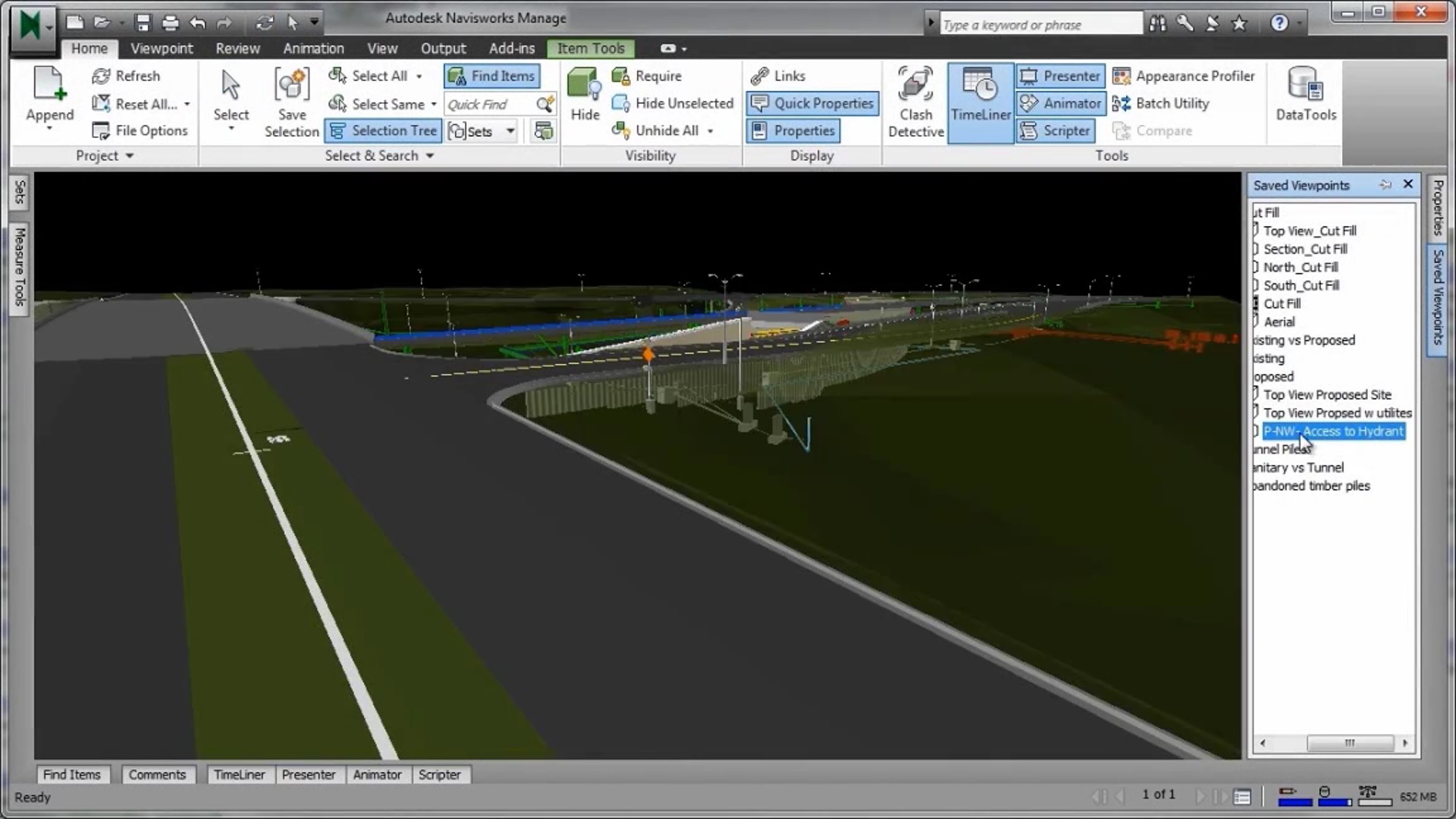
Most of Autodesk’s BIM for Infrastructure solutions are combined in its Infrastructure Design Suite, intended to be used by professionals such as civil engineers, utility designers, and urban planners working in engineering and construction firms, utility companies, and government agencies for transportation, land, utility, and water projects. Similar to the Building Suite, the Infrastructure Design Suite is available in three editions—Standard, Premium, and Ultimate editions—which are progressively more powerful and provide more capabilities. The Ultimate Edition, the most advanced, gives us a good idea of the complete range of capabilities of the Infrastructure Design Suite: it includes applications such as AutoCAD, AutoCAD Raster Design, and AutoCAD Utility Design for traditional CAD-based workflows; 3ds Max Design for rendering and visualization; ReCap for working with point clouds (used for infrastructure projects in the same way as building projects); Revit for using BIM—as those in the building industry know it—on individual structures such as bridges or power plants, along with Robot for their structural analysis; Navisworks for coordination, review, and project management before and during construction (just as with buildings), as shown in Figure 1; and finally, two infrastructure-specific applications, AutoCAD Civil 3D and InfraWorks. These are really the crux of the Infrastructure Design Suite and what differentiates it from other Autodesk products like the Building Design Suite. Let’s explore these two applications in more detail, and the difference between them.
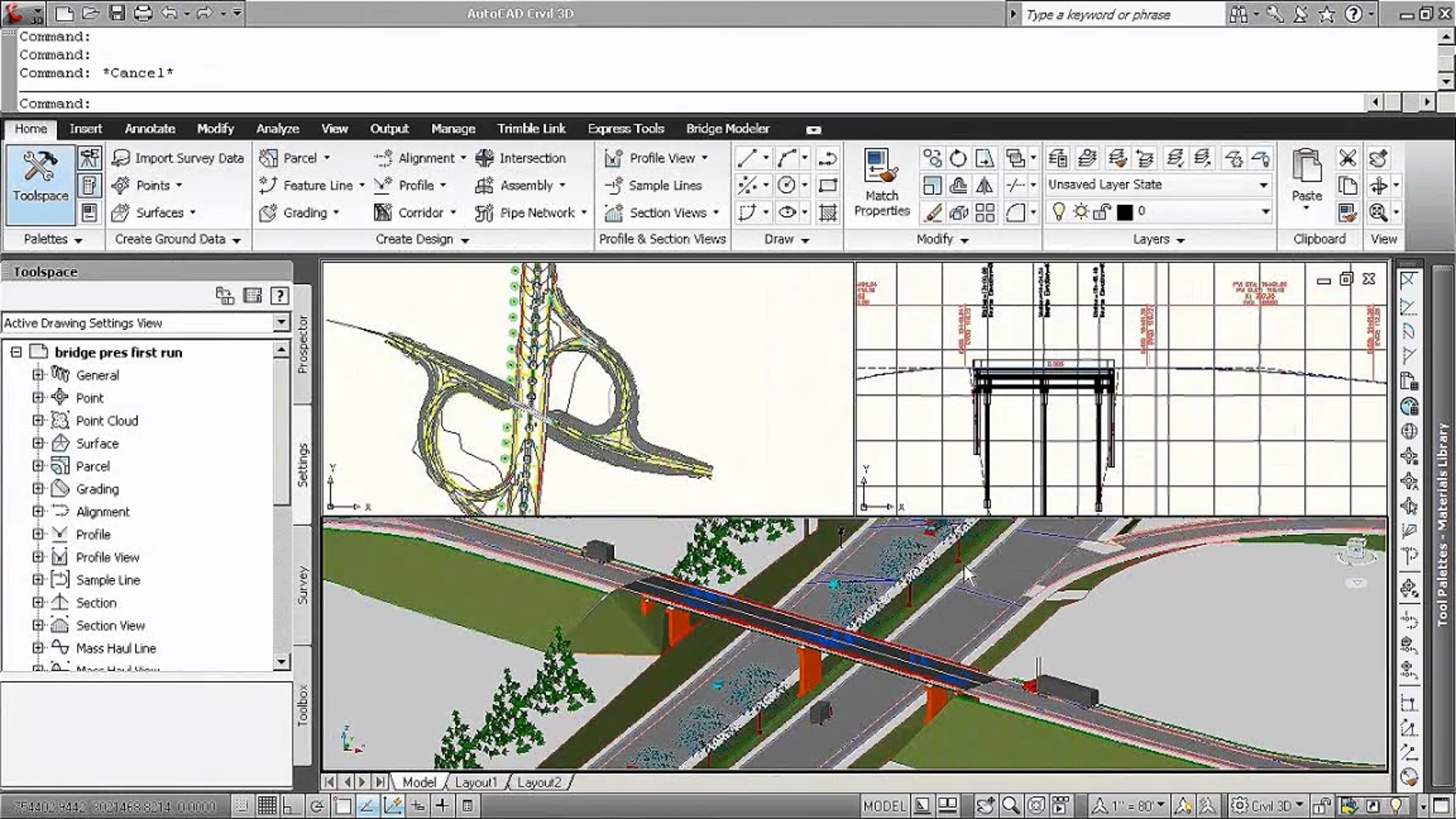
As the name suggests, AutoCAD Civil 3D is primarily a civil engineering application, used for the detailed design, analysis, and documentation of individual infrastructure projects such as a traffic junction, a network of roads, a bridge, a dam, and so on. Although AutoCAD Civil 3D is based on AutoCAD, as its name suggests, it is more like Revit in its ability to model infrastructure components in 3D and carry detailed information about them and their relationship to other components. Just as with buildings, the “ideal” in infrastructure design is to have a single model that can be used at every stage, starting from initial design all the way through to construction, operation, and maintenance, and this is the driving force behind tools such as AutoCAD Civil 3D. The underlying data model is rich enough to allow the different kinds of analysis that would be needed depending upon the type of infrastructure being designed. Thus, it enables BIM workflows for civil engineering projects in the same way that Revit enables BIM workflows for building projects.
AutoCAD Civil 3D has four additional modules for specific fields: Geotechnical Module, for importing and modeling borehole data; Bridge Module, for modeling bridges and bridge components (Figure 2); Rail Layout Module, for designing specialty track layout features such as turnouts; and River and Flood Analysis Module, for automating flood plain analysis and mapping. These enable more discipline-specific modeling and analysis to be brought into the infrastructure design process, and it gives the application the ability to design a diverse array of structures.
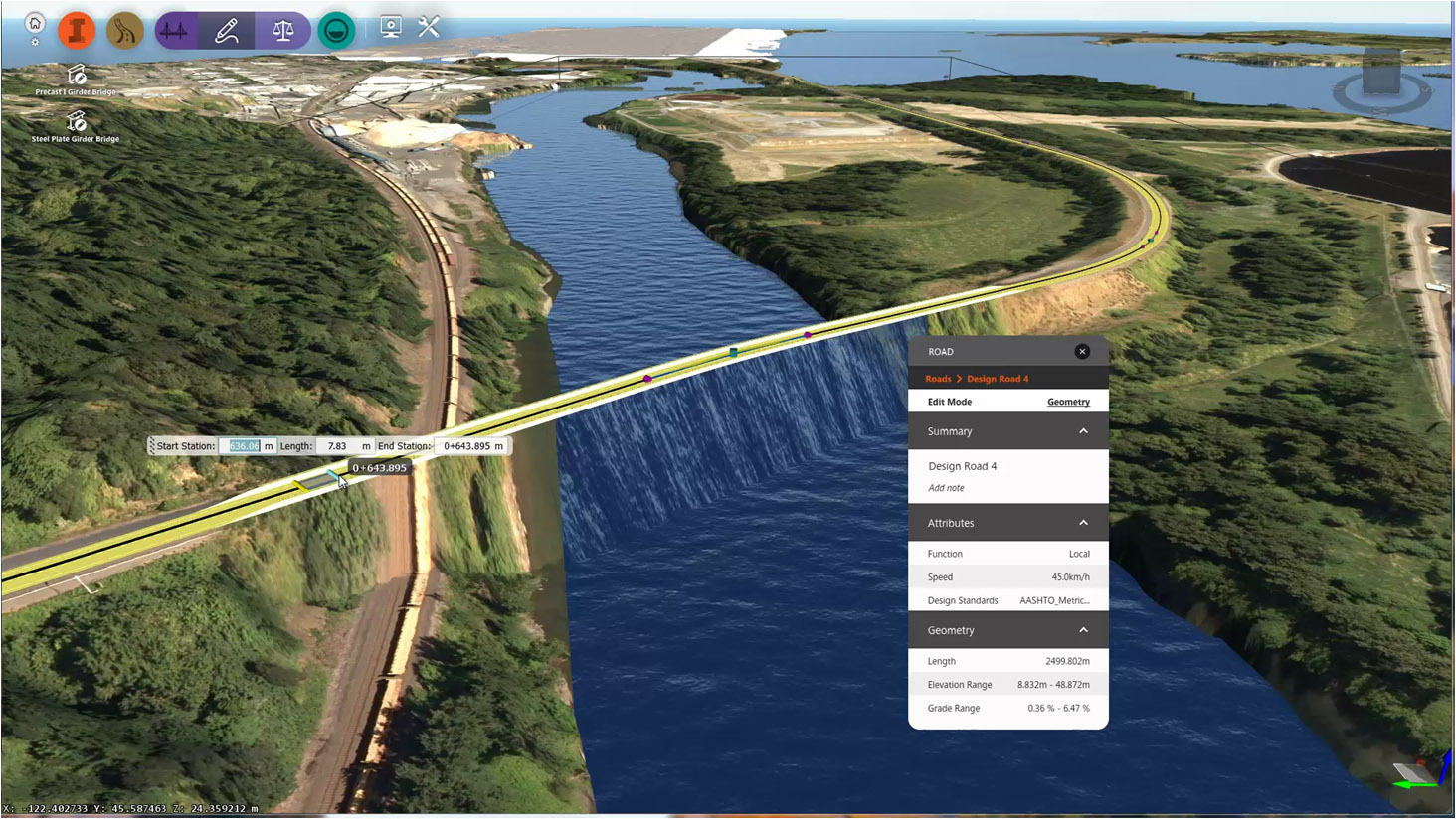
In contrast to AutoCAD Civil 3D, InfraWorks is a tool for the planning, modeling, design and analysis of infrastructure projects, targeted towards city planners, GIS analysts, and architects as well as civil designers and engineers. It was introduced at Autodesk University 2010 as Project Galileo, a technology preview on Autodesk Labs intended to be an easy-to-use planning tool for creating 3D city models from civil, geospatial, and building data, and 3D building models, enabling conceptual infrastructure ideas to be sketched within the 3D city model. Project Galileo itself came from a redesign of the LandXplorer product developed by a German company, 3D Geo, maker of intelligent 3D urban modeling software, which Autodesk acquired in 2008. Once Galileo had graduated from Autodesk Labs and became a commercial product, it was first called “Infrastructure Modeler” before finally being getting the moniker InfraWorks. Throughout its various avatars, the application has always been targeted as a tool for city planners, GIS analysts, project managers, and architects to better understand infrastructure projects in the context of their built and natural environment (Figure 3), to be able to communicate these designs more easily to the public and other stakeholders in the projects; and to be subsequently be used by civil designers and engineers to execute the projects.
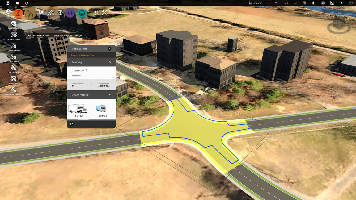
There are two versions of InfraWorks: the version included in the Infrastructure Design Suite, the current release of which is InfraWorks 2015, and InfraWorks 360, which includes all the capabilities of the base product and adds cloud-based collaboration and other services. While both versions include the civil engineering, modeling, and visualizing of infrastructure projects in the larger context that is the raison d'être of the application, the additional capabilities that InfraWorks 360 offers include publishing and managing models online, allowing multiple stakeholders to access and/or collaborate on a project, and enabling access to the project information from the field. It is, of course, accompanied an app (almost a requirement these days)—the InfraWorks iPad app, for viewing and collaborating on InfraWorks projects using a mobile device. In addition, InfraWorks 360 has three additional discipline-specific vertical applications: for roadway design (Figure 4), bridge design, and drainage design. Additional cloud services such as profile optimization and watershed analysis can be leveraged as well, depending on the vertical application in use. There is also a cloud service for corridor optimization for those using the roadway design vertical application.
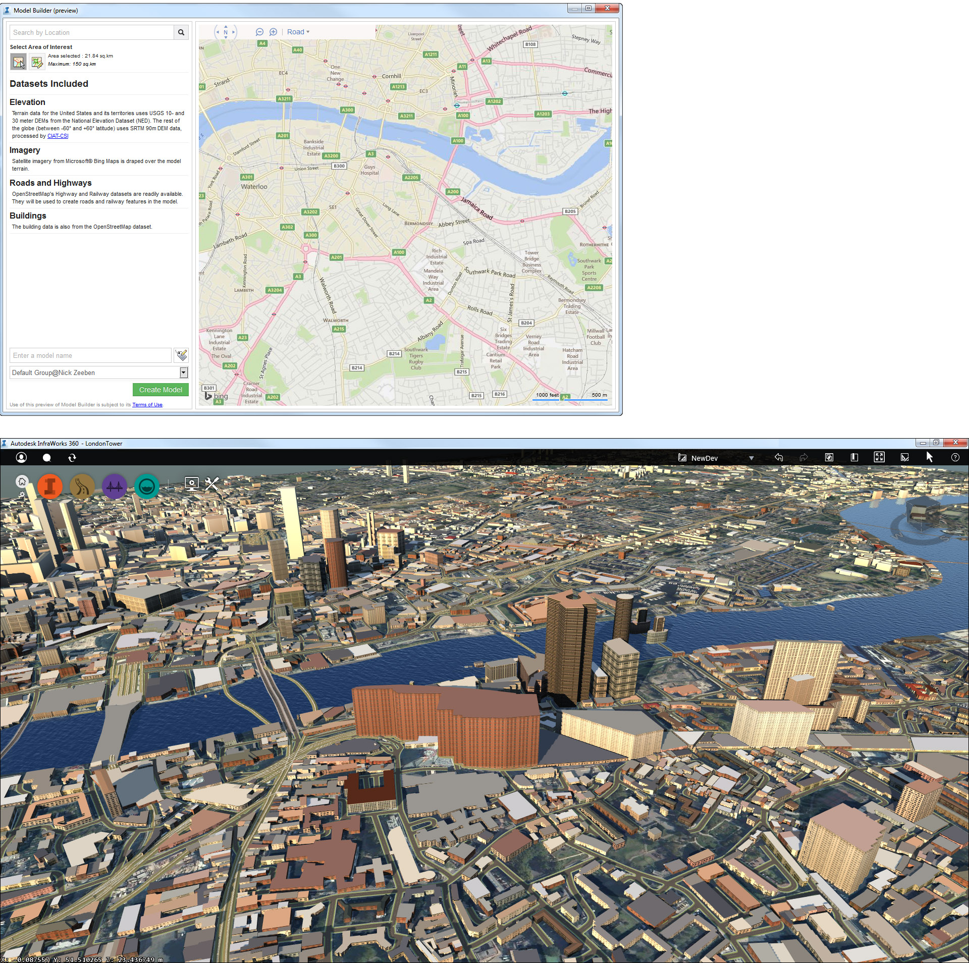
I also had the opportunity to see an upcoming InfraWorks 360 cloud service called Model Builder, which can generate a city model in 3D in real-time using existing published GIS and map data. All the user needs to do is select the region on the map; the corresponding 3D city model is automatically created in about 15 to 30 minutes (Figure 5). This remarkable feature, which was fascinating to watch, is currently available as a preview capability in InfraWorks 360; the fully functional capability will be available at a future release date.
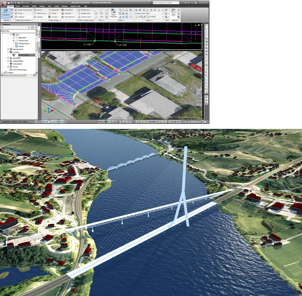
To summarize, again, the main difference between the two applications is that AutoCAD Civil 3D is best suited for the precise detailed design and documentation of specific infrastructure projects. It has been around for much longer and is well established in the civil design community. In contrast, InfraWorks is a more recent application that also includes high-level planning and design capabilities for modeling large neighborhoods and cities as well as evaluating proposed infrastructure projects in the larger context in which they are situated. The difference between the two is well exemplified by the implementation examples shown in Figure 6, where the top image shows the use of AutoCAD Civil 3D in a roadway design project by the City of Riviera Beach in Palm Beach County, Florida, while the lower image shows the use of InfraWorks by Multiconsult AS to design a road improvement project, including road expansion and a new bridge, and visualize it in the context of the existing environment for the Norwegian Public Roads Administration. InfraWorks 360 is even more powerful, with its access to related cloud services and the added features found in the vertical applications, making it capable of efficiently managing larger-scale infrastructure like cities as well as miles of road or pipeline. With its ability to capture and model data-rich existing conditions, InfraWorks 360 can be used to quickly generate and evaluate early design concepts as well create detailed presentations of project proposals for clients. Its cloud-based model-sharing capability also enables it to be used to communicate design proposals to a bigger audience, including the public and other project stakeholders.
There are several aspects to consider before we can make some meaningful progress in developing intelligent city models. One is the issue of file size. If BIM models of individual buildings are so large and unwieldy, how much more would BIM models of neighborhoods and cities be? Needless to say, we need some intelligent software solutions to optimize the size of these super-huge models without detracting from their ability to store relevant information about themselves. Applications like Navisworks, with their efficient compression capability, provide some useful insights which can be replicated, but we would need this in several orders of magnitude to work efficiently with city models. A good example is how a building would be represented in a city model—a lot less information about it needs to be captured in a city model than in its full-fledged individual BIM model. On the computer hardware side, fortunately, we can anticipate less problems, as with the increase in memory, processing power, graphics, and OS innovations, computers are getting increasingly more powerful.
Another significant issue is that of openness. This is very well captured by a member comment in the AECbytes Discussion Forum on the topic of Intelligent City Models: “ … for BIM to work at the city and regional scale, it has to be platform-neutral, because cities are made up of buildings and infrastructure designed by an infinite number of architects, engineers, landscape architects, urban planners, and scientists, and they all use different BIM and CAD packages.” Solutions such as AutoCAD Civil 3D and InfraWorks described in this article do support model formats such as DWG, DGN, IFC, KML, and Sketchup (SKP), as well as infrastructure-specific standards such as OpenGIS and CityXML (which we will explore more closely in a later article), but we need to determine if this is sufficient or if we need even more open and non-proprietary solutions.
For an intelligent city model to be really useful, we need a good set of analysis tools to start with and many, many more as the field develops. Of course, it is helpful in and of itself to have a model with all the infrastructure components corrected located in relationship to each other, so that you can immediately determine any location information, for example, knowing exactly where and how all the utilities run under a road when any repairs need to be made. But there’s so much more that an intelligent city model can facilitate through its ability to support analysis—for example, impact of a proposed new development on traffic; evacuation of residents in the event of a natural disaster; monitoring of water consumption in the event of mandatory water rationing; and so on. The list of potential uses is endless. Autodesk does plan to develop some analysis tools to accompany its infrastructure modeling products, but we will need many more. Here again, the importance of an open platform is evident, so that the development of analysis tools can be undertaken by any other vendors, consultants, clients, or even cities themselves.
There are these and so many more issues to explore, and future AECbytes articles will continue to research and highlight developments in the field of infrastructure and city modeling, including dedicated reviews of relatively new but potentially promising solutions such as InfraWorks. While there are many AEC professionals working on infrastructure projects to whom this topic is directly relevant, advances in the field of city modeling should be interesting to everyone, because better planned cities directly impact all of us. This sentiment is perfectly captured in another Discussion Forum comment on this topic: “IC (Intelligent Cities) touches every aspect of life and can really make the world a better place to live.”
Lachmi Khemlani is founder and editor of AECbytes. She has a Ph.D. in Architecture from UC Berkeley, specializing in intelligent building modeling, and consults and writes on AEC technology.
Have comments or feedback on this article? Visit its AECbytes blog posting to share them with other readers or see what others have to say.
AECbytes content should not be reproduced on any other website, blog, print publication, or newsletter without permission.